Reality capture is only the beginning
Most construction teams don't lack images of their site. They have thousands of them: phone photos in a shared album, a 360° walkthrough from last month, video clips from a foreman's chat group, maybe footage from a fixed camera at the gate. What they lack is an efficient way to turn that visual record into an answer to a simple question: is this project on track, and where does it need attention?
Reality capture — the practice of systematically photographing, filming or scanning a construction site — is a necessary first step. But a 360° image by itself only tells you what a location looked like at one moment. It doesn't tell you whether that matches the plan, whether it changed since the last visit, or whether someone needs to act on it.
At Bimefy, we think about this as a pipeline: capture, then understand, then compare, then act. Each step depends on the one before it, and skipping straight from capture to "we now have a lot of photos" is where most reality-capture efforts stall. This article walks through that pipeline in the context of the Bimefy mobile app, and explains why we built it to connect 360° site walks to BIM, planning, progress tracking and issue detection, not just to store images.
What is reality capture in construction?
Reality capture is the process of recording the physical, as-built condition of a construction site so it can be reviewed, compared and shared without a repeat site visit. In practice, teams combine a few capture methods depending on what they need to document:
- 360° cameras (handheld or mounted), which record a full panoramic view of a location in a single pass, useful for walking a site room by room or floor by floor.
- Smartphone and mobile capture, for quick, ad-hoc documentation of a specific area, issue or delivery.
- Fixed and live cameras, positioned at entrances, cranes or specific work areas, for continuous visibility rather than a periodic walk.
- Drones, for site-wide context, roofs, façades and areas that are difficult or unsafe to reach on foot.
- Point clouds, generated from overlapping captures, which add a spatial dimension to what would otherwise be a flat collection of photos or video.
None of these methods is inherently better than the others - they answer different questions. A 360° walkthrough suits interior progress documentation; a fixed camera suits tracking a single area over time without someone having to be there. The rest of this article focuses mainly on 360° and mobile capture, since that's the primary workflow in the Bimefy mobile app, but the same capture-understand-compare-act logic applies across all of them.
Capturing reality with the Bimefy app
Bimefy has iOS and Android apps built around a simple field routine: walk the site, capture what's there, and make it available to the rest of the project without extra steps.
The app supports Insta360 cameras - currently the X3, X4, X4 Air, X5 and X6 - so a site team can pair a 360° camera with their phone and capture a full walkthrough rather than a series of individual photos. The workflow is intentionally short:
- Walk the site with the camera running, ideally the same route each time so captures stay comparable over time.
- Capture the environment: corridors, rooms, work areas, anything relevant to that visit.
- Upload and process the capture from the mobile app, without moving files between a camera, a laptop and a shared drive first.
- Associate the capture with the project, so it lands alongside the BIM model, the schedule and the rest of the project data instead of a personal photo library.
- Make it available to the team: site managers, BIM coordinators and anyone else who needs to see the current state without visiting in person.
Keeping this short matters for one reason: repeatability. A capture routine that takes twenty minutes and several manual steps gets skipped the first time someone is busy. One that fits into a normal site walk is more likely to actually happen every week.
From 360° imagery to spatial understanding
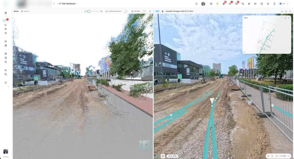
A single 360° image is easy to view but hard to use spatially - it shows you a location, but not where that location sits relative to the BIM model or the rest of the site. This is where point clouds come in.
When a set of captures overlaps enough, Bimefy can generate a point cloud from them: a 3D representation built from the captured imagery. It's worth being precise about what that point cloud is for. The goal isn't "we generated a point cloud" as an end in itself - a point cloud is an intermediate spatial representation. Its job is to let a 360° capture be placed and calibrated against the BIM model and the site's coordinate system, so the system, and the people using it, know exactly where that capture belongs.
Put differently: the point cloud is the bridge between "here is a photo of a corridor" and "here is what the BIM model says should exist in that exact corridor, at this exact location." Once that bridge exists, reality capture stops being a standalone media library and starts sharing the same spatial context as the model and the plan.
From pixels to progress
This is where reality capture starts paying for itself. Once a capture is placed correctly in the project's spatial context, it can be compared against two other things that already describe the same location:
- Planned - what the schedule says should be built by this date.
- Modeled (BIM) - what the design says should exist at this location, independent of time.
- Reality - what the capture actually shows.
Linking BIM elements to the construction schedule is what gives the model a time dimension - a 4D view of the project, not just a spatial one. With that link in place, a team can move from a vague question like "what does the site look like?" to specific ones: What has actually been completed here? What should have been completed here by today? Is this area ahead of or behind the planned sequence? Where is reality diverging from the plan, and by how much?
These are the questions our progress-tracking use case and construction site monitoring tooling are built around, and they only work because the underlying capture is tied to the same model and schedule the rest of the team already relies on.
Reality capture as a time machine
A location shouldn't be captured once and forgotten. Captured regularly, it becomes a timeline: a record of what a specific spot on site looked like on every visit, not just the most recent one.
That history is useful in ways that go beyond progress percentages. Consider a common dispute on site: a subcontractor claims an area wasn't ready when they arrived to start their work. Instead of digging through phone galleries or old messages, a team can open the project's capture history for that location and see exactly what was, and wasn't, in place on the date in question. Our 360° vs. BIM comparison use case is built around exactly this kind of side-by-side review, at whatever point in time you need it.
Fixed and live construction cameras extend the same idea to areas that benefit from continuous visibility rather than a periodic walk: a crane zone, a site entrance, a critical work area, so the timeline isn't limited to whenever someone last walked through with a 360° camera.
From object detection to issue detection
Computer vision on construction imagery is often framed as "recognizing objects": detecting a wall, a beam, a worker, a piece of equipment. That framing undersells what's actually useful. Recognizing that a wall exists in a photo isn't, on its own, valuable information. What matters are the questions that follow: Should that wall be there yet, according to the schedule? Does what's visible match what the BIM model specifies for that location? Has work that should have happened here actually happened? Is something visibly different from what was expected, a missing element, an unexpected obstruction, incomplete work? Does this specific spot need someone's attention, or is it fine?
The goal of applying AI to a construction site isn't to detect more things. It's to detect the things people actually need to know about. That distinction is why Bimefy's AI project assistant is built around surfacing progress and deviations in context, tied to the BIM model and the schedule, rather than producing a generic list of detected objects. The same reasoning applies to safety: PPE and hazard observations are only useful when they're tied to a specific, actionable location and moment, which is also why site monitoring pairs reality capture with camera and security integrations rather than treating detection as a standalone feed.
It's worth being clear about current capability here too: this is about surfacing visible deviations and observations for a person to act on, not about a system making autonomous decisions on a site.
What if your BIM could see reality?
Put the pieces together and the underlying idea is straightforward. Reality capture provides the eyes: what a site actually looks like, right now, at this location. BIM provides the spatial and design context: what's supposed to exist there. The construction schedule provides the missing time dimension: what's supposed to exist there by this date. AI's role is to help connect those three sources and surface what's worth a person's attention, rather than leaving someone to compare them manually.
We're planning to embed a Bimefy webinar walkthrough of this exact workflow here. In the meantime, you can find our ongoing discussions on reality capture, BIM and construction site intelligence on Bimefy's YouTube channel.
One site, multiple views of reality
360° site walks are one input among several, not the only one. Depending on the project, the same site can generate signal through mobile captures, fixed and live cameras, drone imagery, the BIM model itself, and the construction schedule.
Treating these as separate systems recreates the same problem reality capture is supposed to solve: another data source nobody has time to cross-reference. The goal at Bimefy is to bring them together in one place, tied to the same project, rather than adding another isolated tool to the stack.
Reality capture should produce answers, not more data
Higher-resolution cameras and easier capture workflows will keep improving, and that part of the story isn't in question. But resolution isn't the bottleneck. The bottleneck is turning a capture into an answer: what changed, whether the site is on schedule, and where someone needs to look next.
That's the standard we hold Bimefy's reality-capture workflow to: connecting reality to the plan, before problems become delays.